Saturday, May 14, 2022
Weather - Sunny, then raining, then sunny again; temps ranging from 72F to 80F, depending on where we were
Steps - Shaun: 14,489, Shannon: 12,196
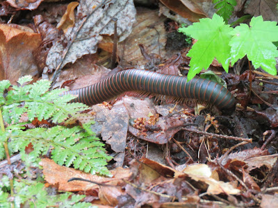
Varmints - multiple turkeys, one blue ridge two-lined salamander (yay!), two American giant millipedes (yuck! - Shannon), two pleasing fungus beetles
 |
| Shaun looking for salamanders |
Today we had intended to drive down the Newfound Gap road, visit Clingmans Dome, and hike 3.5 miles to Andrews Bald, but the weather forecast dissuaded us from attempting what will be our most challenging hike when it was likely to rain and thunderstorm. Instead, we decided to do the auto tour of Cherokee Orchard Road/Roaring Fork Road. At the mid-point of the loop is Grotto Falls, a 2.8-mile hike to a waterfall that you can walk behind. We just hoped the rain would hold out until we finished the hike (spoiler alert! It did not.)
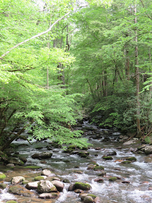
We got a late start due to the reconnoitering of our plans and then stopping for coffee for Shannon and then stopping to pee at the Sugarlands Visitors Center, so we didn't start on Cherokee Orchard Road until almost noon. Shannon read from our trusty road guide while Shaun skillfully navigated along the narrow, precarious roadway. Cherokee Orchard Road dropped us onto the Roaring Fork Loop Road, which was blessedly one way and followed the course of the Roaring Fork River. True to its name, the river really did roar as it rushed through rocks of all sizes on its way down the side of Mount Le Conte.
We made it to Grotto Falls near 12:30pm. We had read that the parking lot fills up really early, and we found that to be true; we had to park on the side of the road a good half-mile from the trailhead. We decided to bring our hiking poles for this excursion, and thank goodness we did! They saved our lives a few times as things got slippery and they helped us up and down the trail much easier than what we experienced on the surprise 2.6-mile Laurel Falls hike.
Though longer than the Laurel Falls hike, we felt like the 2.8 miles to Grotto Falls was easier because there were regular sections of flat ground between uphill sections. There was also plenty to stop and look at, between the plants, rocks, streams, and terrain.
Unfortunately, we were about halfway to the falls when it started to rain. And rain. And rain some more. Now, we're pretty hardy folk, and we don't generally care about rain, especially since we were prepared for it, as much as we could be. Still, hiking uphill over rocks and mud with a cold, steady rain falling on us, trickling down our necks and soaking our clothes, is not really our idea of fun. We just kept going, hoping that it would run its course quickly as it had the previous day.We eventually got to the falls, and it was totally worth the climb and the rain. The water was rushing and roaring over an outcropping, and it ran into a series of cascades that we climbed the last section of the trail next to before reaching the falls themselves.
The trail ran behind the waterfall, and we were able to rest there, out of the rain though with a bit of mist taking its place, and eat a small snack. We took our pictures and then started back down the trail.
And what should we find as we ventured back on the trail? The rain was stopping! Yay!
The way down was a little more gingerly because of the big pools of water and slick mud, but we spent a lot more time looking at the pretty flowers, delicate mosses and miniature ecosystems on broken logs, brightly colored foliage, and small animals and insects we discovered. Along the way, we saw our first salamander (though we thought it was a skink until we looked it up later), a snail who very nicely posed for us, and a giant millipede.
Shannon went a little crazy with Shaun's big camera, photographing all the little things we missed in the rush up to the falls. Here are a few artsty-fartsy shots she took in her frenzy:
Once back at the car and only slightly damp, having mostly dried out on the way down (thank you, moisture-wicking fabric!), we decided that it was time for lunch. Shannon found a picnic spot on another road covered in our auto tour book, Greenbrier Road, which is much less well known and thus, much quieter than the Roaring Fork Loop Road. We finished out the latter with a stop at the Place of a Thousand Drips, a cascade that has a bunch of little waterfalls that all come together to run into the Roaring Fork River. In a way, we lucked out with the rain because the drips were actually more like full on streams and very beautiful as a result.To get to Greenbrier Road, we had to return to Hwy 321, the main drag through Gatlinburg, and then head east for several miles. It was a bit disorienting, coming from the lush green oasis of the park, where the loudest noise was the rushing river, back into the lights, music, horns, bells, and congestion of the city. It's amazing that only a few minutes separate them; it feels like lightyears!
We found Greenbrier Road and immediately noticed the difference in upkeep on the road. It's definitely less traveled. It quickly changed to gravel, with plenty of potholes, blind curves, narrow lanes, and drop-offs, which tested Shaun's mountain-driving skills (she was up to the challenge, of course!). The picnic area was adjacent to the Little Pigeon River, but while we could hear it, we couldn't actually see it through the foliage. That was fine, though; the sound of the water was enough for us. We ate our delicious lunch of chips, salsa, and guacamole, apples, celery, and peanut butter, and carrot sticks and hummus. A true smorgasbord!Because we're gluttons for punishment, we decided to continue down Greenbrier Road, even going down both forks in the road, in our quest to find more varmints. Alas, there were none to be found. But we did see thick, dark forests, babbling brooks and rushing rivers, glowing moss, and lots and lots of rocks. From boulders to pebbles, rocks everywhere. Apparently the amazing number of rocks came out of the last ice age, when winters were longer and the freeze/thaw cycle caused chunks to break off of the mountains above. They would fall along the slopes and into the path of mountain streams and that's where they remain.
We left Greenbrier Road before 6pm and started the hour-long trek back to Townsend. Along the way, we stopped to get Shannon some long-awaited ice cream from Mad Dog's Ice Cream and Donuts, and it was awesome.
Back at the cabin, we showered off the layers of bug spray, did laundry, and relaxed after the adventures of the day. Now to figure out what to do tomorrow, with more rain in the forecast!


No comments:
Post a Comment