
Thursday, May 10, 2018
Weather: Sunny, mid-80s
Steps: Shaun - 7,585, Shannon - 6,472


Thursday started with avocado toast and was spent driving in and around Capitol Reef National Park. We stopped in Torrey at the General Store, where we stocked up on various items, including vegan cheese and homemade bread. From there, we headed down the road toward the park, stopping at overlooks and pullouts along the way.

The first major viewpoint we visited was the Goosenecks Overlook, which included a half-mile roundtrip hike up to a spot that looks out on a stretch of twists and turns in Sulphur Creek below. The canyon shows the rock layers really well, as well as the erosional work the river had done over millennia.


We stopped to view the Castle (named for obvious reasons) before reaching the visitors center. It was super busy, but the displays (including a table-top view of the entire park) were very informative. Capitol Reef was named by early settlers to the area for the round domes of white Navajo sandstone that resemble the domes of capitol buildings, and the ridge of rocky cliffs that forms a natural barrier in the land, much like a coral reef does in the sea. The ridge was caused by uplift underground that tilted and exposed the underlying rock layers. Uneven movement along a fault line led to a difference of more than 7,000 feet between the height of the layers on one end of the ridge and the other, giving it a folded appearance. The ridgeline is called the Waterpocket Fold, of which Capitol Reef is just a part.
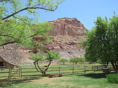

The abrupt change in elevation provides relative shelter from weather, and at the ridge’s base, a floodplain sustained a number of communities through the years. Most recently, Mormon families established the town of Fruita and planted orchards of apples, pears, and peaches. The National Park Service still maintains the orchards, and the remaining homestead was the next stop on our journey.
One of the houses has been turned into a store and bakery, selling pies made from fruit from the orchards. We bought two individual-sized pies (Shan’s was a la mode) and ate outside at a picnic table. Shaun ended up getting sick from hers, but they still tasted good going down.

One of the houses has been turned into a store and bakery, selling pies made from fruit from the orchards. We bought two individual-sized pies (Shan’s was a la mode) and ate outside at a picnic table. Shaun ended up getting sick from hers, but they still tasted good going down.


Aside from the geological history, we also saw evidence of the cultural history of the region on our drive. We came across petroglyphs from the Fremont Culture, which lived in areas of Utah from around 600 to 1300 CE, just off of the main Highway 24. We also saw a now-defunct uranium mine that dates back to 1901.
Before leaving the scenic drive in the park, we stopped to have some lunch in a picnic area in Fruita. There was a river nearby, big trees provided shade, and we felt like we were in heaven.

After lunch, we decided to take a less-traveled scenic loop up over the ridge and along the edge of the Waterpocket Fold by following the Notom-Bullfrog Road to Burr Trail and then back up Highway 24 to our lodgings. Along the way, we saw the lifted and folded rocks for which the Waterpocket Fold got its name, some with trees growing out of cracks, the Henry Mountains, which are to the east of the fold, mesas, hoodoos, and oyster shell fossils in the rocks from when the area was an inland sea.


We reached Hwy 24 and saw what we had missed in the dark the previous night. There were lots of vistas, a reservoir, and a change in elevation up to 9600 feet, the highest point on our trip. By that point it had become really cold and poor Shaun was not prepared, wearing only a raincoat and shorts.

Also along the road were about 50 bajillion turkeys, elk, and deer, including kamikaze ones that made the drive a bit harrowing.
We returned to the cabin and packed in preparation for a long day on the way to Moab. Finally, we ate a low-key dinner there and bedded down for the night.

No comments:
Post a Comment